After years of trying to get an elusive BLM permit for New Mexico's Rio Chama it was a pleasant surprise when, in 2011, my friend Earl Atnip won one of those coveted slots and invited a few close friends to join him on a 3-day river trip that turned out to be memorable in every way. Our permit was for July 29-31, and fourteen of us met at Cooper Ranch (which is usually referred to as El Vado Ranch) just below the dam at El Vado Reservoir near Tierra Amarilla, New Mexico to camp the night before launching. The river was at a decent, though not optimum, level and the weather was just about perfect, especially compared to what we left behind in Dallas and other parts of Texas where temperatures were well into the triple digits range during 42 consecutive days of hot, dry summer.
Rio Chama is a major tributary of the Rio Grande. The river forms in far southcentral Colorado, just above the New Mexico border in the San Juan Mountains of Carson National Forest in Archuleta County, then flows about 120 miles to its confluence with the Rio Grande just north of Espanola in Rio Arriba County, New Mexico. The upper river is characterized by huge boulders that create difficult holes, sizeable drops and hidden dead-fallen trees that test experienced whitewater boaters. Above El Vado Lake in New Mexico the river is a Class IV to IV+ whitewater run of great intensity. Below El Vado Lake the river is a Class II to III run for almost anybody with intermediate or higher level whitewater skills. This historic river has been used by humans for nearly 10,000 years, dating from the time when camels and wooly mammoths roamed the southwestern United States. In 1988, the 24.6 mile section known as Chama Canyon was designated as a "Wild and Scenic River" by the U.S. Congress.
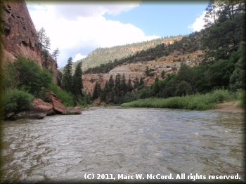
The walls in Chama Canyon rise to a maximum height of some 1,500 feet above the river, though only in limited areas. Most of the riverbank is lower mountains and nearly flat plains. Verdant hues of trees and brush are everywhere along the river. The canyon rim and sloping uplands are frequently punctuated by steep sandstone and shale outcroppings. Inside the canyon is a plethora of geological wonders including high, steep canyon walls and escarpments consisting of rock slides, ledges, pinnacles and ridges. The bedrock of Chama Canyon is shale, basalt, tuft, sandstone, granite, quartzite and other types of rocks, some of which formed about 110 million years ago.
Our group was composed of trip leader Earl and his sons Alec and Zach of Plano, Texas, Anita Goss of Rockport, Texas, George Lackey of San Angelo, Texas, Sam Sloan, Eric Neilsen, Angelo Piersanti and his son Max, and me, all from Dallas, Texas, Randy Stovall of Carrollton, Texas Bryan Jackson of Forney, Texas, Ted Schupbach and Michael Mariano of Taos, New Mexico. A couple of others who really wanted to make the trip had to cancel at the last minute and alternates were unable to fill their slots, but our group size was perfect for the campsite space available, especially since most of us had separate tents.
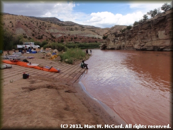
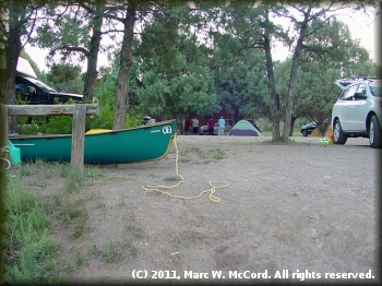 Cooper Ranch is a privately-owned campground and launch site with tent and RV camping, cabin rentals and a nice camp store. We were especially fortunate that Earl reserved the campsite closest to the river access so that we had to carry our gear just across the road to get ready to launch. Our party consisted of two inflatable canoes, two inflatable kayaks, three hard canoes and six hard kayaks, all solo except for one canoe. We had met Dale, the River Ranger, who would check us in and make sure that we had all required gear, at a store in Taos on the day before our launch, and we had a great conversation with him about river conditions and paddling in general. Dale is a very nice guy, experienced whitewater paddler and great source of information. The following day he quickly assessed our preparedness and signed us off, so we were good to go. Dale told us that the fire ban restriction had been lifted because of increased humidity in the region, but we were already prepared for a fire-less trip.
As usual for our group, collocquilly known as "The Crack 'O Noon Club", we were on the river right around noon, which was fine with us since we only had a short paddle to our first campsite at Aragon Canyon where we camped at Christmas Tree Rock about 10 miles below El Vado. We were not the only ones on the river, but campsites are assigned on a first come basis, and we got a good one that gave us adequate privacy and quiet. Thanks to the eternal vigilance of the BLM our campsite was spotless and beautiful. The fire ban, which existed before our arrival, had been lifted the day we launched, but we did not bring firewood, so we camped sans a campfire. Spacing between tents was adequate, but we still needed earplugs to ward off the snoring of some members of our group. In one case, we would have needed earplugs anywhere within about 100 yards!
 The first day on the river was uneventful. We paddled on mostly flatwater with a few very minor Class I to I+ riffles and small rapids that posed no challenges, especially since the majority of us are very experienced in Class III or higher whitewater. What the river lacked in "excitement" was more than offset by much cooler temperatures than we had in Texas and immense natural beauty. The surrounding mountains were covered with a variety of trees and brush including ponderosa pine, douglas fir, pinyon, juniper, mountain mahogany, gambel oak, serviceberry, as well as riparian areas with their cottonwoods, box elder, willows and hackberry trees in varying shades of green contrasted against the reds and browns of the sand and rocks. Scenery was A+ everywhere we looked. After a short few miles we started getting into the canyon setting with its much prettier topography, even though the mountains were still quite small.
Due to the fire restrictions in place when we packed for the trip we left stoves and cookware at home, opting for Heater Meals - better than MRE's , not not anywhere nearly as good as our normal fare on river trips. That did, however, make for lighter and more spacious boats, which is something with which many of us are not all too familiar. The company of good friends coupled with the astounding beauty of Chama Canyon more than offset the limits of our cuisine. The scents from the trees and brush were very pleasant, and contributed to the enjoyment of the trip. The most tiring part of the whole day was packing boats to launch and then unpacking what we needed for camping.
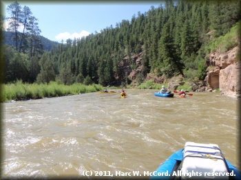
 Day Two was where the fun began as the rapids grew larger and more frequent. We started much earlier than usual for our group, and with only 8 miles to our next campsite at Huckabay Canyon we chose a leisurely paddling style most of the time, getting more "into it" as we ran rapids before returning to a casual ride enjoying the river and taking photographs, some of which are included with this report and the attached slideshow. The river was dropping in level slightly, and while we were above minimum levels we really wanted a little more water rather than less. Still, we never had to get out and drag boats anywhere other than when we beached for breaks or campsites. Almost all Texas rivers were too low to paddle at all, so Rio Chama was refreshing in every way.
The walls grew taller and closer as we entered the heart of Chama Canyon. Mostly clear, blue skies accentuated the lush green hues of the tree-covered mountainsides. The water was a clear, greenish brown color that contrasted to the brush and trees along the banks. We were fortunate to have only moderate winds that did not impede our progress and paddling conditions were nearly perfect in every way. The only drawback to this trip is its short length. If this river was about three to five times as long, then it would be one of my favorite destinations because is is barely further than going to the Rio Grande along the Texas-Mexico border and half as far as going to Utah for Green River trips. Of course, there is still the issue of permits, and that is a dampening factor, but we keep trying year after year.
Our campsite at Huckabay was nothing short of fantastic. We had the first campsite going downriver. Access was a breeze, even though we did have to carry gear up a short cliffbank with improvised steps created by years of use. Behind our camp was an excellent, small canyon for hiking and observing the effects of rain, snow and ice on rock formations and plant life over many millenia. The slot canyon was an interesting place to explore, and we encountered people from a group in a neighboring camp while there.
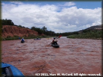 Our last day on the river brought something different - rain! It did not rain much where we were, but apparently it came down a lot heavier in the mountains to the west because our greenish-brown water suddenly started turning red as side streams fed into the river carrying with them an abundance of flotsom from decaying trees and other plants. Ironically, the best rapids were still ahead, and they were about to get even better than we had anticipated. The long boulder garden rapid just above and down to Chavez Canyon Public Access proved to be the most challenging, fun and exciting rapid we encountered on the entire river. Our tandem canoe found its way into boulders that capsized it and made recovery a little tricky. Several of us beached our boats, grabbed rescue gear and headed back upriver to assist, but the passengers in that boat did the majority of the work and got it onto the bank with more damage to the boat than to themselves, and the boat damage was not significant - it just received a deep dent in its bow from collision with an immovable rock.
At that point several lesser experienced paddlers decided to take out and await our return after we reached the Big Eddy Public Access. It probably seemed like a good move at the time, but what we encountered downriver from Chavez was easily negotiated, and any of them could have made it without incident. Still, we try to err on the side of caution, and nobody tried to talk them out of stopping at Chavez. It was their decision and it was right for them. But, they did have a wait of at least three hours before we could complete our run and get somebody back upriver to get them. Along the way to Big Eddy we encountered the highest and closest mountain walls of the entire trip, especially at "Screaming Left Turn Rapid", which is rated as Class III, at about 30.1 miles. It was truly "canyon paddling" at that point. We expected "Screaming Left Turn Rapid" to make an attempt to slam us into the mountain wall on river left, but it was actually an easy ride with little effort required to avoid the collision. In fact, even with the rain we got there were some shallow channels of gravel bars to avoid getting into the canyon at the right turn near the end of the rapid.
We encountered two more somewhat significant rapids, Overhang Rapid (Class II) at about 30.6 miles and Adobe Ruins Rapid (Class II) at about 31.1 miles that were exciting at the slightly higher level and made even more "eventful" because of the red water on which we were now paddling. Debris in the water certainly made reading the river much easier - currents were well defined and we could watch the flotsom for indications of what the river wanted to do to our boats. The rest of the trip was awesome and fun. The rest of the run was rather "pedestrian" in that we encountered no major challenges.
 Other groups were at the Big Eddy Public Access when we arrived there, some ending their trips and others getting ready to go down to Abiquiu Reservoir on a short, flatwater trip. Some of those ending trips at Big Eddy had probably started at the Chavez access below which no permit is required, and that is a popular reach for local paddlers, especially because of the numerous good rapids and fantastic scenery.
Paddling in New Mexico is not easy for those who do not live there. Typically, the rivers run low most of the time, and it is a long way to drive for many of us, so timing is everything. Luckily, there is a somewhat constant release schedule from El Vado Dam during summer months, depending upon the winter snowpack and its subsequent melt, as well as agricultural drawdowns that can limit available water for release. With any luck one of us will get another permit soon and it will be for a date a little earlier in the release season, but I will go to Rio Chama anytime I can get on the river when there is enough water to float my boat. The photos with this report and the attached slideshow attest to why people love this river so much! I cannot wait to get back there again.

