One of the rarest whitewater events in Texas occurs whenever Somervell and Hood Counties around Glen Rose get a heavy rainstorm and the Paluxy River floods. Just outside Glen Rose is located Dinosaur Valley State Park through which the Paluxy flows, or should I say sits? The normal "flow", if you can call it that, is about 17 cfs, and most visitors to the river go there to photograph dinosaur footprints in the limestone riverbed. This is the locale of my shortest river trip ever and two of my fastest trips ever, all of which left an indelible memory that thrills me just to think about them.
 In late 1996, the Dallas-Fort Worth area got pounded by a major rainstorm that severely flooded the Paluxy River. Nobody in their right mind goes to the river when it is rising, or even after it starts dropping until it gets down to at least 4-5,000 cfs. The river was flowing at 2,750 cfs the day I ran it for the first time in 1996, and I know it is a trip I will never forget. It was a cool November day, and I had donned my US Navy Seal wetsuit, a cumbersome and heavy quarter inch thick foam rubber two-piece diving suit made by US Diver. That suit was very warm, but it was definitely NOT made for paddling. The arm motion of paddling wore my underarms raw, even with a base layer underneath, because of the cut of the arms which usually trail a diver. But, it was all I had, and with temperatures in the 50's and cold water I wanted some protection. I had no idea just how soon I would need that protection, but I found out!
Whenever the Paluxy rises paddlers from all over North Texas flock there. Many whitewater enthusiasts keep their boats and gear loaded and ready to roll in the event the river rises, and they have a series of excuses to tell bosses about why they are going to miss work for a day or two. The Glen Rose population increases whenever the river floods, though the new arrivals do not hang out in town. Our group met at a rock ledge off a county road just above the state park on a Saturday morning. Many other area paddlers were also there - perhaps as many as 50 or more baoters altogether. After setting up our shuttle at Big Rocks Park in Glen Rose we prepared to launch. I was following a group of kayakers who attacked the launch and headed for river left to avoid standing trees (the river was out of its banks and a few trees were in the water on river right.) I attempted to take my canoe where the kayakers had gone, but my 16-foot Old Town Appalachian was too cumbersome to cut across the strong eddy line to the other side, so I got swept to river right where I hit a submerged, deadfall tree truck and flipped about 50 yards from where I launched. The swift currents carried me downriver at a rapid pace until a kayaker came to my rescue and helped me get to the river right bank. Other boaters corralled my runaway canoe a couple of miles downriver, and I walked the banks to get it.
Upon getting back to my boat I decided that I had seen enough of the Paluxy on that day, so I dragged my heavy boat across a very muddy cow pasture to where my vehicle could get access on a fairly hard surface so that I could load up the boat and drive out without getting stuck. My total river time on that trip was a matter of a few minutes, including the swim, and stands as my shortest trip ever.
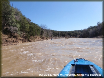
Fast forward to July 4th weekend, 2007. It rained heavily right before the holiday weekend just as it frequently does in the dry Texas summer just in time to knock outfitters off schedule for a financially rewarding weekend. The Paluxy rose to over 28,000 cfs, and we waited until the weekend to make our journey to Glen Rose. There were six of us in four solo canoes and two solo kayaks, all of whom paddle together quite a lot. The river was down to about 1,190 cfs when we launched far upstream at Baker's Crossing off SH 51 in Hood County on July 7. We were going to paddle about 21.7 miles down to Big Rocks Park. It was a gorgeous day and the river was really moving.
 The first half of the trip down to Edwards Crossing was fast and mostly easy Class I to I+ whitewater when we had rapids at all. That section is fairly flat, and the real excitement begins right below Edwards crossing adjacent to the Lanham Mill Cemetery. The only casualty was a broken spare paddle that got caught in the low-hanging branches of a tree along the river right bank about two miles below Baker Crossing and then snapped as the canoe carrying it sped downriver. We made the first 10.3 miles in about 2 hours of easy paddling.
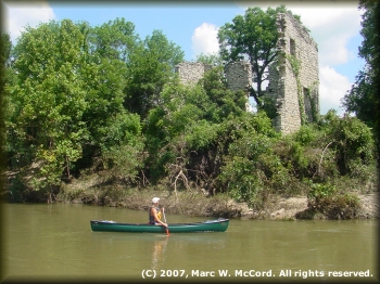
Key features on the upper reach of the river include the remnants of the former Lanham Mill on river left between Baker's Crossing and FM 51, and the Lanham Mill Cemetery at CR1008 (Edwards Crossing) with its historical marker telling of the times when people lived and worked in the vicinity of today's river crossing. The photo to the right is of the Lanham Mill site on river left about a mile and a half below Baker's Crossing. Most of my photography on both the 2007 and 2012 trips was taken above Edwards crossing because from there down I had very little time for photography due to larger and more frequent rapids starting with running the low-water bridge on CR 1008 and the rapid just below it. The last half of the trip is almost non-stop excitement, and an occasional show stopper rapid that takes your breath away while getting you very wet even if you stay inside your boat.
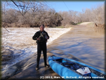
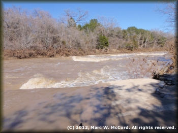
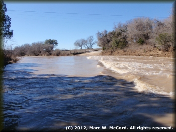 By the day of our run the river had already carried the bulk of loose debris (tree trunks, etc.) far downriver and into the Brazos River east of Glen Rose, so the channel was relatively clear of any floating obstacles. But, the current was screaming like a banshee, and was only slightly tamer than the 2012 run at 2,600 cfs when the river was REALLY humming! We did not have to paddle much, other than to steer, on either trip. The 2012 trip with Stan Pully, who was paddling his SOAR S-14 inflatable canoe (I was in my SOAR S-16) was definitely faster, reaching Edwards Crossing in a mere 87 minutes. We were averaging over 6.2 mph without breaking a sweat. We stopped at the submerged low-water bridge, had lunch, took a few photos of the cemetery and the river above and below the bridge, and then headed on downriver for all the fun that awaited us below.
On the 2007 trip I took photos of the other five guys running the rapid below Edwards Crossing before running it myself. We all started above the bridge, cruising through the small hydraulic immediately below the bridge and into the waiting arms of a Class II rapid. Some of those photos appear in the slideshow linked at the top of this report. The 2007 trip was uneventful, though packed with fun and excitement all the way down to the SH 205 low-water bridge where a new high bridge had been built to replace the former low-water crossing. Shortly after our trip that low-water bridge was completely removed following the deaths of a girl trying to help a friend who was swimming in the strong hydraulic and could not get out, and then a game warden three days later as he was dragging the river for her body. The game warden had died two days before our trip, when the river was still a lot higher. At 1,190 cfs, the low-water bridge had a drop of about 3 feet on its downriver side and it created a VERy strong keeper hydraulic current that was difficult to escape.
 In 2007, at a "lowly" 1,190 cfs the rapids were intense and challenging. I was paddling my Old Town H2Pro solo whitewater canoe and my friend Walter was paddling my Old Town Cascade solo whitewater canoe. Those boats are a lot of fun when the rivers are fast and wild because they have enough rocker to turn quickly and enough stability to allow a paddler to play without flipping easily. For me, those are two worthy assets to have in a boat. We made child's play out of the rapids above the state park, but it was there that things started getting a little more intense. First, the waves and holes were getting bigger. Second, they were coming much more quickly in succession. After every rapid I had to bail my boat, as did Walter, Sam and Chris. John and Ken were in kayaks with spray skirts, so they did not have the same problems keeping water out of their boats.
CR 2008, the scene of my crash and burn in 1996, runs alongside the river off SH 205 about a mile below where it crosses the river at Edwards Crossing, and it is the common starting point for paddlers wanting a shorter run. Most of the really great rapids are between this point and Big Rocks City Park. A lot of kayakers like to use this access because they can run down to the state park and take out at the end of a 2 or 3 mile play run, taking time to surf waves and play in holes, often shuttling back to the put-in and doing it again ... and again until they get tired and hungry. Our group prefers to see much more of the river, so this point is merely a landmark for us, but it signals the beginning of some hairy rides that will flip those who are either too inexperienced or too complacent, especially in canoes. In 2007, none of us had any problems on these rapids getting down to the park, and in 2012, Stan and I weren't even concerned in our SOARs - those boats are just too stable to worry about problems with boat control or stability on anything below Class IV water, and they even eat Class IV with proper steering control. In both years we were enjoying this river immensely, and wishing that it would rain a lot more often in this northern edge of the Texas Hill Country. All too infrequently do we get to enjoy the Paluxy River.
Just as we got to the state park the river had two prominent flows around a small island above which was a zig-zag turn left and then right with the island right in the middle of the two turns turn. Most of the group went left around the island, but Walter and I saw some interesting looking waves along the right side, so that's where we went. What we did not see from above the island was a huge boulder that normally would have been high and dry, but on this day was about 20 feet off the bank in the current. Walter approached it toward the middle of the river and got sucked into the rock sideways, lifted up and over the rock and set back down facing downriver, all in a couple of seconds. He was able to paddle hard and found his way back into the mainstream of the river without incident, though I would love to know what was going through his mind as it happened.
 Seeing what happened to Walter, I immediately spun my bow toward the left and tried to avoid the boulder. Instead, the very strong current caught my stern and sucked me backward into and up over the boulder plopping me down with my bow toward the middle of the river and my stern about 5 feet up on dry land. I sat there dazed and wondering what had just happened. With a little effort, which including climbing out of my saddle and pushing off, I was able to move my boat back into the mainstream, and then proceeded to find a line through a series of giant waves and holes that were as exciting as any whitewater run I had ever had at that point in my life. Unfortunately, everybody was too busy running rapids, bailing boats or trying to get boats under control for the next rapid to take any photos, and that is a shame because those would have been some prized shots!
In 2007, when we reached the SH 205 low-water bridge, which we had scouted before launching upriver, Sam, Chris, Ken and John opted to portage the bridge on river left, an easy effort to get around having to risk the hydraulic below the bridge. I had already picked my line and decided to run it, so I took off as fast as I could paddle, made the drop, did a quick stern pry and spun around to go back and surf the hydraulic for a couple of minutes while Walter watched from above as he was deciding whether to run or portage. Finally, Walter decided to follow my lead and run the bridge. As he entered the drop he got slightly off-center and went over the edge of the bridge with his bow about 15-20° to the left. The hydraulic caught the boat and immediately flipped it dropping Walter into the hydraulic from which he could not escape. It took us at least ten minutes to finally drag Walter out of the river using a throwbag and three guys pulling him. It took another 20 minutes for the hydraulic to release the boat and spit it out so that we could continue to the take-out. Walter was badly shaken and spooked by his experience. He is a very strong swimmer, but he was incapable of freeing himself from the death grip of the the recirc.
A few weeks later the old low-water bridge was removed with such precision that there is not even a sign it was ever there. Only by looking at the old roadway down to the river on each bank can one see that a bridge had previously spanned the river. On the run Stan and I made in 2012, there was no bridge to run, but I thought about Walter's experience as we paddled past that point just before the US Highway 67 bridge that signals the approaching end of the trip. Over the years that bridge has killed numerous people, but the death of the game warden was the final straw leading to its removal.
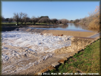 The final 4.5 miles from the SH 205 high bridge to Big Rocks City Park has numerous Class I to I+ rapids that are fun, but too challenging for competent boaters. After crossing under the US Highway 67 bridge about 2.3 miles below SH 205 you are entering Glen Rose and you will start to see houses and commercial buildings on either bank. There are several possible take-out points below US Highway 67. The first is the one most widely used today. It is at Heritage Park where there is ample parking, restrooms with flush toilets, water fountains and a small pavilion suitable for lunch stops or debriefing about a great river trip. You can also take out on either side above the dam, though there is very limited parking on river left and none immediately adjacent to the river on the right. As you can see from the photo at the right, the new dam is a monster with a killer hydraulic, so care needs to be taken when approaching it. Paddlers can safely portage the dam on river right, put back in just below the dam, and then paddle out into the "big rocks" to play, or else go to river left to the parking area where your trip can end. And, if you have not yet had enough paddling, then you can paddle the short distance down to Squaw Creek or the Brazos River and take out at Tres Rios RV Campground where a take-out fee will be charged.

