Every so often we get an opportunity of a lifetime and being ready to accept that opportunity can make all the difference in one's life. Such was the case when George Lackey first told me about his plan for a return to the Yukon Territory in March, 2008, when he asked me to publish notice of the trip on the Dallas Downriver Club website. At that time George was just fishing to determine if there would be any interest. Much to his surprise he learned that a LOT of paddlers wanted to do this trip, and I was one of them.
Initially, George had designed a trip of 13 days on the Big Salmon and Yukon Rivers where the water flows fast and cold above the 62nd parallel. In all, about 18 people expressed strong interest, and the deal was done. George set about working out the logistical details for a trip starting July 27 and ending August 9. The plan was to meet in Whitehorse, the capital of the Yukon Territory, on July 25 or 26, make all final arrangements and preparations, then shuttle to Quiet Lake on July 27, starting the trip the following morning.
 In the end we had 12 people make the river trip and one more went with us to Whitehorse, then flew back home before the trip due to work obligations that prevented her from participating in the excitement of a true wilderness trip far removed from any vestiges of civilization. Half of us drove up to Whitehorse while the other half flew in. Those of us who drove up included Dave and Paula Sanders from San Antonio who were on vacation driving through the western US, and Kathy Smith, Roger Zimmerman, Zoltan Mraz and myself from Austin, Victoria, Sugar Land and Dallas, Texas, respectively. By driving up we got to see a whole lot more gorgeous scenery that those flying into Whitehorse and we saved about $500.00 per person by taking our own canoes, gear and supplies rather than having to pay the exorbitant prices one has to pay for anything in Canada.
George, our fearless leader from San Angelo, Texas was joined on airplanes by Gary Tupa (San Antonio), Debra Johnson and Kathy Wakefield (Athens, Texas), Bill Forshey (Austin, Texas), Chris Klotz (Colorado) and Michael Portman (Austin, Texas), all of whom arrived in Whitehorse less than one day before our group of four. George had selected Kanoe People, owned by Scott and Joanne McDougall, as our outfitter for canoe rentals and shuttles. From the outset Scott and Joanne were golden in their support and assistance, and I would strongly recommend their services to others visiting the Yukon.
For those in our group on the road trip it was everything we imagined, and a lot more. We met at my house in Dallas, loaded Roger's truck and trailer, then headed out on July 18, stopping in John Martin Reservoir State Park between Lamar and Las Animas, Colorado to camp our first night on the road. We arrived late and departed early, so we did not get to see much of the area, but the second day had us going to Wyoming where we camped at Middle Fork Campground on the Powder River in Bighorn National Forest near Buffalo. That drive was truly scenic, in a rolling hills prairie sort of way, with the Colorado and Wyoming Rocky Mountains looming in the distance. Again, we arrived late, but managed to find a great campsite right by a creek that feeds into the Powder River, and we got some great photos of that area before starting out the next morning for Montana.
 Day three had us stopping by for a walking tour of the Little Bighorn Battlefield National Monument in Montana, and a step back into history where one can feel the spirits of that horrible battle as it played out over two days of intense fighting. Personally, I was chilled to the bone and quite emotional as I walked that battlefield for the second time in my life, the first time being in 1988, on my way to Yellowstone to help fight the forest fires that devastated so much of the forest that year. My Cherokee and Lipan blood found kindred spirits among the First Nations people who fought that great battle to protect their families, their ancestral lands and their hallowed way of life. We ended the day at Kings Hill Campground in the Lewis and Clark National Forest just southeast of Great Falls, Montana.
The next day we drove across the remainder of Montana, then proceeded to cross the Canadian border where we were carefully scrutinized by Canadian immigration officials, but after a delay of less than one hour we were admitted into Canada with a promise to spend lots of money, then leave the country at the end of our trip, which was exactly what we planned to do anyway. We camped at the end of day four along the Milk River in Writing-on-Stone Provincial Park, and that was where the real excitement began. The park is named for the numerous petroglyphs that are found there among the rock formations called hoodoos, towers of rock that have been chiseled away from erosion caused by rain, ice, sand and wind over many centuries.
Milk River was home to the first Canadian hoodoos we saw, and our campsite was just yards away from a significant collection of them that were much smaller than what I am accustomed to seeing, but oh so much more accessible. Before continuing the following day we took the time to explore the formations and capture them in many photographs. Roger, Kathy and I availed ourselves of this opportunity while Zoltan lounged around taking it easy (he's an old man, you know!) Of course Roger, at 70, is a few months older, but seems to be in very good shape, especially when it comes to exploring areas with a steep gradient that makes us younger guys (I am 60) have to work hard to keep up with him.
Milk River was moving at a very respectable speed, and I was wishing we had the time and a shuttle so that we could run that river. It looked VERY inviting, and I intend to go back and paddle it as soon as I can, but then, I saw a thousand rivers up there that I would love to paddle. Unfortunately, they only thaw for about 2-3 months, so it will take a lot of Canadian trips to do them all.
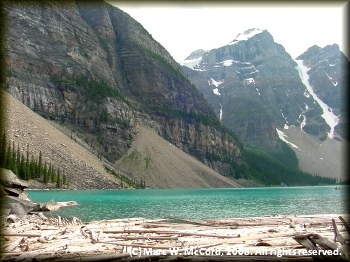
 Our plan for day five was to go near Lake Louise to a quaint little remote place called Moraine Lake in Banff National Park where Zoltan had camped 42 years ago. The place was well off the beaten path, and Zoltan remembered it as absolutely breathtaking in its natural beauty. As we approached Moraine Lake the first thing that took our breath away was the fact that it was no long "undiscovered". In fact, it looked more like a busy tourist day at Disneyland. We were barely able to find a slot long enough to park the truck and trailer, then had to join hundreds of other visitors who went there to admire the scenery and take pictures. We did the same, and it was a couple of hours well spent, but there is no longer any camping there, as it has now developed into a hotel resort with plenty of opportunity to spend money. They even had a canoe outfitter there to provide trips on the lake. But, it was a stop well work making.
Not being able to camp at Moraine Lake, we headed out for some unknown destination and ended up at Mosquito Creek Campground, also in Banff National Park, and it had quite a few campers, but we found a campsite that was perfectly situated right by the creek, and it was absolutely beautiful. Gorgeous snowcapped mountains, dense forests and clean, clear flowing streams of ice cold water were all around us.
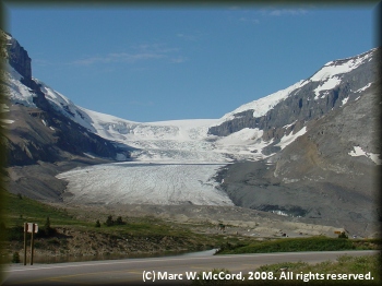
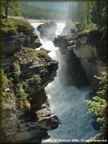
On our sixth day we took the Trans-Canada Highway through the land of glaciers, and it was more beautiful than I could ever have imagined. We stopped by Athabasca Falls, a great place for a serious whitewater paddler to end his life in spectacular fashion, documented by hundreds of tourists with video and still cameras. Athabasca Falls is a glacier melt drop of about 80 feet on the Athabasca River, which flows out of the Athabasca Glacier in the Columbia Icefield, and it has some significant whitewater rapids above and below the falls. We took a lot of photos at the falls, which were just stunning to behold. The roar of the water dropping over that crevice cut through solid rock was ear piercing, and if you are in Alberta, then you simply MUST see this sight!
We continued on through Alberta past the magnificent Columbia Glacier into British Columbia to Moberly Lake Provincial Park, where we camped for the night. Immediately upon arrival the park host told us that a grizzly sow and two cubs had been sighted just a short distance away - time to break out the Klaxon horns and bear spray that we brought with us! I just KNEW we should have brought a rifle or shotgun! But, we were armed with our cameras and running shoes (I know, you cannot outrun a grizzly bear, but I CAN outrun Zoltan, Roger and probably Kathy!)
As luck would have it we never saw the grizzly family, but we did encounter the nuisance after which the creek and campground where we stayed the previous night were so aptly named, and they ate more than we did! It was our first major encounter with the famous national bird of Canada - the mosquito. It would NOT be our last encounter with them. More on that later...
 In keeping with what we had already come to expect on this trip, Moberly Lake was every bit as magnificent as every other campsite we had enjoyed. The campground was a short distance off the highway, but it was embedded among tall, spruce trees alongside a creek across which was a range of tall mountains with snow adorning the peaks. It was a very popular campground, but we managed to find two open campsites adjacent to each other where we pitched out tents and proceeded to make it our home for the night.
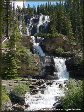
The further we drove into Canada the prettier and grander the mountains became. Snowcaps adorned nearly every one of them, and it was late July! What was especially inviting was the respite from 100+ degree days and low 90's nights in Texas. We actually had one night with frost on our tents and other nights with temperatures in the low to mid-40's. Days saw highs in the upper 50's to lower 70's. Who could ask for better summer weather? Now, if only we could get rid of those damned mosquitoes that seemed to be following us everywhere!
On day seven we drove to a provincial park near Fort Nelson, B.C., on a road that continued our path of scenic mountains, forests and fewer and fewer small towns. It was time to start topping our fuel tank at every place we came upon, and we were
carrying an extra ten gallons as a backup. We also had to plan our trip so that we were traveling during times when gas stations would be open for business. To this point we had seen very little in the way of exotic wildlife, and that really surprised me. Did I mention that we did see plenty of mosquitoes?
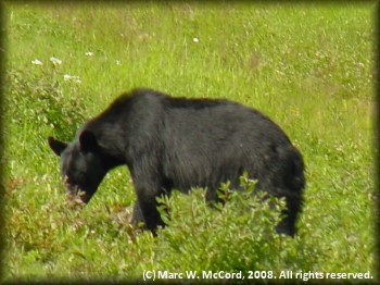 On day eight everything changed. Leaving Fort Nelson the mountains grew larger, the area became much more remote, and we began to see wildlife. Now, we had four major quests - to see and photography bears, moose, elk and caribou. All along the highway we saw signs warning us of crossings for various antlered or furry creatures over the next X number of kilometers (they don't know how to measure distance in miles up there, eh?) It was not long before we saw the first black bear grazing alongside the road, so we naturally did the very thing you are never supposed to do - we stopped the truck, got out and started taking photos. The bear was quite accommodating for a few minutes before becoming annoyed by our presence and walking into the forest. We did NOT follow it! We may be dumb, but we ain't stupid!
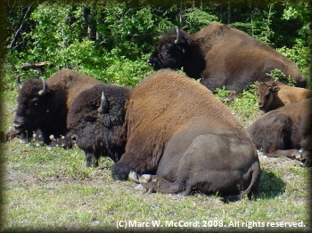
Then, after a short time we saw a second black bear, and we photographed it. Not too long afterward we saw the third and fourth black bears. Suddenly, we came upon a very large herd of 40-50 buffalo grazing and laying alongside the highway, and some of them were very large - much larger than those I have seen in Texas, Colorado, Wyoming and Montana. Maybe they eat mosquitoes up there. They would certainly find an inexhaustible source of food if that were their main diet! A little later we saw another black bear, and again we stopped for a few photos. By now, we were making jokes about it being just another black bear, but we stopped each time and took a few photos anyway.
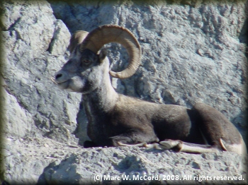 Coming around a mountain uphill curve we saw a moose calf running down the highway - grizzly bait, as the locals called it. Before we could get any photos we were passed it, and other traffic prevented our being able to stop, so we missed that one. But, shortly thereafter we saw a flock of bighorn sheep, which the locals referred to as thinhorn sheep, though I do not know why. We got a LOT of photos for them ranging from little newborns to old, giant sheep lying on ledges overlooking the highway. Many of them were apparently licking the salt from the roadway, and we spent a good 45 minutes gazing at them and taking photos. We stopped by a gas station / general store where we saw a bumper sticker that read "There is not a single mosquito in the Yukon. They are all married with very large families." We can attest to the veracity of that claim! Thank heavens for DEET - the 100% variety that I bought at Wally World before leaving Dallas, and I wished that I had bought twice as much!
We saw one other black bear before reaching our campsite on the Teslin River, where we got rained on just as we were striking camp the next morning. At this point we were only about two hours from Whitehorse, and we had a rendezvous with the rest of our group later that morning, so we did what we had been doing every morning on this trip - we had hot oatmeal with either coffee or hot cocoa (for those of us, namely me, who do not drink coffee.) There is nothing quite like a hot Swiss Miss to start the day off on a good note!
We arrived in Whitehorse around 11 AM, and went straight to the Riverview Hotel, our base for this trip. Most of the others were already checked in, though they were out shopping for the supplies they would need on the trip. Our group had just about everything we could ever need, plus a little more, so we just "topped off" our supplies with some snack items and we were done. We went across the street to Kanoe People and met Scott who helped us get ready for our departure the next day.
 Scott informed us that the Big Salmon River was flooded, and that all available campsites along the river were probably underwater - very COLD water. He suggested that we paddle the Teslin down to the Yukon Confluence, then follow the Yukon down to Coal Mine campground just above Carmacks, which was our intended destination. We agreed that was a great idea, then loaded everything we would be taking with us, other than what we would need overnight, into Scott's trailer on which he would carry the four canoes we brought plus four that he was renting to our group of four tandem and four solo boats. We purchased river maps and discussed campsites, fishing along the river, wildlife to watch for and avoid, etc. We purchased pepper spray and rented a satellite phone, though he only had the Globalstar phone available, and it turned out to be all but worthless. If you are going outside the US, then you really need an Iridium phone because other service is not reliable, and that proved to be the case when we needed to make calls.

