The Verde River forms at Sullivan Lake, where Big Chino Wash and Williamson Valley Wash merge south of Paulden in the Big Chino Valley of Yavapai County, then flows south by southeast about 170 miles to its Salt River confluence just northeast of Scottsdale and Phoenix. Along the way, it passes through parts of three national forests (Prescott, Cococino and Tonto), the cities of Cottonwood, Clarkdale and Camp Verde, and lands belonging to various tribes of the Apache Nation, private landowners and the State of Arizona. It is a perennial stream in a state known for its "dry" rivers, but it is not always boatable, and may have navigable flows in some reaches when others are too low to paddle. Its waters come from snowmelt in the mountains around the three forests, as well as seasonal monsoons. Surrounding lands are vastly disparate in nature, ranging from densely-forested upland plateaus to canyons to desert lowlands, each with its own diverse plantlife, animals, birds and fish. Beginning about 70 miles below the headwaters is a reach of 40.5 miles that is designated as "Wild and Scenic" by the US Congress, where the river and surrounding lands are perpetually protected against development and overuse.
Between Perkinsville and Beasley Flat lies about 55 miles of gorgeous river flowing through a beautiful and scenic river valley characterized by desert riverbanks, willow and cottonwood trees, ocotillo, Saguaro cactus and a verdant ground cover of desert scrub. The river flows as a Class I to II stream with usually gentle currents and a moderate gradient. Paddle trips can be taken year-round if there has been sufficient recent rainfall around Sullivan Lake to keep the river flowing, or not at all during drought years. This reach of the river flows past the confluence of Sycamore Creek on river left, the towns of Clarkdale, Cottonwood and Camp Verde, Dead Horse Ranch State Park and Camp Verde State Historical Park, ending in the "scenic" portion of the river that has been designated as "Wild and Scenic". Most adjoining land along this reach is private property, and care should be exercised to avoid trespassing without advance permission.
The river is very remote, though access at the small towns is good where paddlers can find places to stay (other than the usual riverside camping, if so inclined), food and supplies, restaurants and other services and amenities. Dead Horse Ranch State Park offers an excellent place to stop and explore the surrounding area. Permits are not required for private, non-commercial groups, but upon entering the "Wild" section of the "Wild and Scenic" area group size is limited to a maximum of 15 persons and no more than 15 horses, cattle or other livestock per group. Personally, I could never get a horse or cow to ride in my canoe, but the area is popular for many outdoors recreational activities including horseback riding, camping, hiking, mountain biking, bird and animal viewing, nature photography, hunting, fishing and other activities. Be sure to pack the camera, because there is much to see and photograph along this river that is a green oasis in the midst of a large desert state.

Yavapai County of central Arizona. Prescott is just a few miles to the southwest, Flagstaff is just to the northeast and Sedona is very near to the east. Prescott and Tonto National Forests are home to this reach of the Verde River.

Flagstaff 55 miles; Phoenix 122 miles; Tucson 240 miles; Albuquerque 383 miles; Salt Lake City 577 miles; Denver 710 miles; Oklahoma City 924 miles; Dallas 1,095 miles; Austin 1,085 miles; San Antonio 1,112 miles; Houston 1,271 miles; Little Rock 1,263 miles; Kansas City 1,249 miles (all distances are approximate and depend upon starting point, destination point on the river and route taken.)

The Verde River flows clean, clear and cold from its headwaters to the Salt River on the outskirts of Scottsdale, Tempe and Phoenix. Flow is dependent upon winter snowmelt in Prescott National Forest for normal season paddling, and may be augmented by monsoonal rainfall in July through September for late summer through early fall paddle trips. Typically, you would prefer a flow of at least 400 cfs, but that is unusual other than in March. The river can be boatable at lower flows, but may require occasional walking and carrying or dragging through shallow areas. At flows above about 3,000 cfs, which are VERY rare, trees and brush lining the riverbanks become serious hazards to navigation. See table below for average monthly flows:
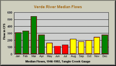

January through April is the primary season for trips on this section of the Verde River, where the water is free-flowing, and March historically has been the best month. A second season MAY exist from August through December, depending upon seasonal monsoons. Like all Arizona rivers, the Verde may not have a navigable season at all in drought years. Typically, the river can be boated any month of the year, though flows may be very low, at which time the bone zone may be very hard on boats and paddlers.

There are no significant hazards on this section of the Verde River other than cold water temperatures. Rapids are Class I to II, and are infrequently spaced along this flatwater section. Being prepared for high elevation and springtime Arizona paddling conditions avoids most problems. Because the best flow conditions occur during colder months wearing wetsuits, drysuits or water-repelling garments is advised for prevention of hypothermia. Be sure to carry extra clothing, in dry bags, for the eventuality of getting wet while paddling.

Perkinsville Road (FR 173) at 0.0 miles; US Highway 89 Alternate, between Cottonwood and Cornville, at about 23.0 miles; White Bridge River Access Point (RAP), about 0.2 miles NW of the SH 260 bridge, near IH 17 at Camp Verde, at about 45.0 miles; West Clear Creek RAP, off Salt Mine Road (across highway from the Shell Mini-Mart on SH 260), at about 51.8 miles; Beasley Flat RAP, off FR 334 (CR 328) about 3 miles off FR 574 (CR 163), at about 55.0 miles. There may be other access points along this reach.

Excellent campground facilities are available midway through this trip at Dead Horse Ranch State Park, located at the Sycamore Creek confluence, and Jerome State Historical Park, near Cottonwood, as well as Fort Verde State Historical Park at Camp Verde near the take-out for this section. Primitive, natural campsites can be found along the river, but care should be taken to avoid camping within the floodplain any time there is a likelihood of rain due to the potential for flash flooding.

There are no known liveries or outfitters operating along this section of the Verde River. Plan on setting up and running your own shuttles.

This is the last of the "easy" part of the river above Horseshoe Reservoir. Scenery is awesome and wildlife is abundant. Rapids are Class I to II and the river is usually low and slow, though things can get tricky when flows start to approach 600 cfs, and downright dangerous for anybody with less than strong intermediate level whitewater skills at flows exceeding about 3,000 cfs. The river valley is very remote and peaceful, with little traffic due to limits on commercial operations, though no permits are required for private parties. The towns of Perkinsville, Cottonwood and Camp Verde offer places to get food and supplies, dine in restaurants or stay in a motel if tent camping is not your forte, in which case it begs the question, "Why the hell are you out here in the first place?" Surrounding the river is a wild and undeveloped area that is rich in hunting, fishing, bird and animal watching, mountain biking, hiking, photography and other recreational pursuits in the Great Outdoors. Unlike most of Arizona, the Verde River Valley is green and beautiful, contrasted against shades of brown and tan in the adjoining desert areas. It is sometimes possible to paddle here almost any time, but the river is almost never very high, and in drought years it might not be navigable at all, so be sure to check the gauges and consult with Rangers at Tonto, Prescott or Cococino National Forests for current river conditions before journeying a long way to play. As has been said on most river descriptions, BRING YOUR CAMERA!


